Topics |
||
Geographical Regions of the Arabah and Geographical Description |
||
|
|
|
External References |
||
|
|
|
Preface: After coming across the term arabah on several occasions, it seemed necessary to determine just exactly how this word is used and to what geographical area it refers. We find this word affixed to Moab on many occasions (the Arabah of Moab), we find this same word affixed to river and to sea. Furthermore, this word is used in several places which are quite distinct from one another. Finally, arabah is translated heavens in the KJV of Psalm 68:4, and this has affected its translation in dozens of subsequent translations.
Note: The entirety of this doctrine is going to be of interest to very few. There is probably more information than you need either in A Brief Summation of the Doctrine of the Arabah or in The Primary Uses of the Term Arabah.
1. According to ZPEB, the Arabah is the valley beginning south of the Sea of Galilee and extending down as far as the Gulf of Aqaba. This would include the Jordan Valley and the area around the Dead Sea (mostly to the east of the Dead Sea). There will be a picture below.
1) Fausset: The Arabah is the deep sunken gorge extending from mount Hermon to the Elanitic gulf of
the Red Sea; the most extraordinary depression on the earth. The Jordan rushes for 150 miles
through its northern part (el Ghor) by lakes Huleh and Gennesareth, to the deep abyss of the Dead
Sea. The Ghor extends to precipitous cliffs, 10 miles S. of the Dead Sea. Thence to the gulf of Akaba
it resumes its old name, wady el Arabah. In Jos_11:16; Jos_12:8, the Arabah takes its place among
the natural divisions of the country, and in Deu_3:17 in connection with the sea of Chinnereth
(Gennesareth) and the Dead Sea.
![]()
2) ISBE: the Arabah refers to in general a barren district, but is specifically applied in whole or in part to
the depression of the Jordan valley, extending from Mount Hermon to the Gulf of Akabah.
![]()
3) Smith: The Arabah refers more particularly the deep-sunken valley or trench which forms the most
striking among the many striking natural features of Palestine, and which extends with great uniformity
of formation from the slopes of Hermon to the Elanitic Gulf (Gulf of Akabah) of the Red Sea; the most
remarkable depression known to exist on the surface of the globe.
![]()
4) Arabs call this area el-Ghor.
2. ʿĂrâbâh (עֲרָבָה) [pronounced guh-rawb-VAW], as found in the Old Testament, is used in several different ways, which will be listed below. In general, the Arabah is the unpopulated and desert area extending up from the northeastern tip of the Red Sea, on up along the eastern site of the Dead Sea on up to the Sea of Galilee. This also took in the area around the Jordan River and some portions in southern Judæa. The first 6 or 7 uses below will be subsets of that land mass. The context of the passage will indicate just exactly what portion is being referred to.
3. The word ʿĂrâbâh (עֲרָבָה) [pronounced guh-rawb-VAW], which we transliterate Arabah, is found 61 times in the Old Testament, but only translated Arabah twice in the KJV (which affects its translation in a dozen or more other English translations). In the KJV, this word is translated 9 different ways (3 of which are quite different from what we would expect):
1) Plain: Deut. 1:1 2:7–8 3:17 4:49 Joshua 3:16 8:14 11:16 12:1, 3 1Sam. 23:24 2Sam. 2:29 4:7 15:28 2Kings 14:25 25:4 Jer. 39:4 52:7 Zech. 14:10
2) Plains: Num. 22:1 26:3, 63 31:12 33:48–50 35:1 36:13 Deut. 34:1, 8 Joshua 4:13 5:10 11:2 12:8 13:32 2Sam. 17:16 2Kings 25:5 Jer. 39:5 52:8
3) Desert: Isa. 35:1, 6 40:3 41:19 51:3 Jer. 17:6 50:12 Eze. 47:8
4) Wilderness: Job. 39:5–6 Isa. 33:9 Jer. 51:43 Amos 6:14
5) Arabah: Joshua 18:18
6) Champaign: Deut. 11:30
7) Deserts: Jer. 2:6
9) Heavens: Psalm 68:4
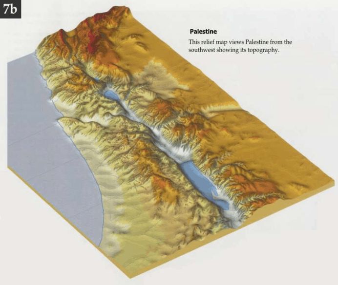 The water to the east (the left) is the Mediterranean Sea. The Arabah is the valley which starts just below the Sea of Galilee
(the small sea area, and includes the Jordan Valley below, and takes in the area around the Dead Sea, and continues
southward (off this map). This is a good topological map of the general area.
From http://www.searchingthescriptures.net/images/maps/007b.jpg
4. The meanings given this word:
1) BDB: desert plain, steppe, desert, wilderness.
2) Gesenius: an arid, sterile region, a desert. With the definite article, this refers to that low region into which the valley of the Jordan runs near Jericho, and which extends as far as the Ælanitic gulf. It is also used to refer to a city in Benjamin (Beth Arabah).
3) Strong’s: From H6150 (in the sense of sterility); a desert; especially (with the article prefixed) the (generally) sterile valley of the Jordan and its continuation to the Red Sea. The KJV translates this word as Arabah, champaign, desert, evening, heaven, plain, wilderness. Strong’s #6160 BDB #787.
4) ISBE: This word indicates in general a barren district, but is specifically applied in whole or in part to
the depression of the Jordan valley, extending from Mount Hermon to the Gulf of Aqaba.
![]()
5) Given the land type which is called arabah, let me suggest that this refers to rocky, barren hills and mountains.
5. Just as we have thousands of areas named with the word desert in it (Mojave Desert, the Arabian Desert, etc.), this term is used for a number of different geographical areas throughout the Palestine area and beyond, where there are generally unpopulated arid, rocky and barren hills and mountains.
6. The root word is ʿârab (עָרַב) [pronounced ģaw-RAHBV], which means to be arid, to be sterile. This verb form and meaning is not found in the Old Testament (there are 4 verbs wit this same spelling, some which are used and some which are not). You may recognize the transliteration of this word and its substantive cognate as Arab. Strong’s #none (related to #6152) BDB #787.
7. One possible key appears to be the use of the definite article in front of this word; then it seems to signify a particular area. Without that definite article, it appears to designate an area with those same characteristics (this is a theory; I have not examined all of the passages yet). In the plural construct, it is generally associated with Moab or Jericho (as in, the plains of Moab).
8. Descriptions of the Arabah:
1) Fausset: The wady el Jeib is the drain of the Arabah, and the route for entering the valley from the N.
Heat, desolation, and barrenness characterize this desert. The sirocco blows almost continually, and
the ghudah, the arta, the Anthia variegata, the coloquinta, and the tamarisk, almost the only traces
of vegetation. The supposition that the Jordan once flowed through the Arabah into the Red Sea is
not likely; for the Red Sea and the Mediterranean are nearly on one level. The depression of the
surface of the sea of Galilee is 652 feet, that of the Dead Sea 1316 feet, below the surface of the
Mediterranean, and so of the Red Sea. The Jordan therefore could not have flowed into the gulf of
Akabah. The northern part of the Arabah drains into the Dead Sea, the land rising from the N. to the
S. The southern part drains into the gulf of Akabah, the land rising from it to the N.
![]()
2) ISBE: The southern portion, which still retains the name of Arabah, is included in the wilderness of Zin
(Num. 34:3). According to the survey of Lord Kitchener and George Armstrong made in 1883, under
the auspices of the Palestine Exploration Fund, its length from the head of the Gulf of Akabah to the
Dead Sea is 112 miles. The lowest point of the watershed is 45 miles from Akabah, and 660 feet
above tide (1,952 above the Dead Sea). The average width of the valley up to this point is about 6
miles, but here a series of low limestone ridges (called Er Risheh) rising 150 feet above the plain runs
obliquely across it for a distance of 10 miles, narrowing it up to a breadth of about one–half mile.
North of this point, opposite Mount Hor, the valley widens out to 13 miles and then gradually narrows
to 6 miles at the south end of the Dead Sea. At Ain Abu Werideh, 29 miles north of the watershed,
the valley is at the sea–level – 1,292 feet above that of the Dead Sea. North of the watershed, the
main line of drainage is the Wady el–Jeib, which everywhere keeps pretty close to the west side of
the valley. At Ain Abu Werideh it is joined by numerous wadies descending from the Edomite
mountains on the east, which altogether water an oasis of considerable extent, covered with a thicket
of young palms, tamarisks, willows and reeds. Twenty–four miles farther north the Arabah breaks
down suddenly into the valley of the Dead Sea, or the Ghôr, as it is technically called. Lord
Kitchener's report is here so vivid as to be worthy of literal reproduction. “The descent to the Ghôr
was down a sandy slope of 300 feet, and the change of climate was most marked, from the sandy
desert to masses of tangled vegetation with streams of water running in all directions, birds fluttering
from every tree, the whole country alive with life; nowhere have I seen so great and sudden a contrast”
(Mount Seir, 214). The descent here described was on the eastern side of the semicircular line of
cliffs formed of sand, gravel, and marl which enclose the Ghôr at the south end, and which are
probably what are referred to in Joshua 15:3 as the “ascent of Akrabbim.” The ordinary route,
however, leading to the plain of the Arabah from the Dead Sea is up the trough worn by the Wady
el–Jeib along the west side of the valley. But this route would be impracticable during the rainy
season after the cloudbursts which occasionally visit this region, when torrents of water pour down
it, sufficient to roll boulders of considerable size and to transport an immense amount of coarse
sediment. South of the Dead Sea a muddy plain, known as the Sebkah, extends 6 miles, filling about
one–half of the width of the Ghôr. During most of the year the mud over this area is so thin and deep
that it is impossible to cross it near its northern end. This whole area between the “ascent of
Akrabbim” and the Dead Sea has evidently been greatly transformed by the sedimentary deposits
which have been brought in by the numerous tributary wadies during the last 4,000 years, the coarser
material having encroached upon it from either side, and the fine material having been deposited over
the middle portion, furnishing the clay which is so embarrassing to travelers
![]() .
.
3) Smith: Through the northern portion of this extraordinary fissure, the Jordan rushes through the lakes
of Huleh and Gennesaret down its tortuous course to the deep chasm of the Dead Sea. This portion,
about 150 miles in length, is known amongst the Arabs by the name of el-Ghor. The southern
boundary of the Ghor is the wall of cliffs which crosses the valley about 10 miles south of the Dead
Sea. From their summits, southward to the Gulf of Akabah, the valley changes its name, or, it would
be more accurate to say, retains old name of Wady el-Arabah.
![]()
9. Even though we are going to find this word used in several different ways, the various writers of Scripture clearly had these uses separate in their minds when they wrote.
10. The map below seems to identify the Arabah as being the portion of that which is south of the Dead Sea, geographically speaking, the latter approach would give us a more homogenous area, looking more like the picture above, for the most part.
11. ZPEB
![]() breaks the Arabah into 3 geographical regions: the Jordan Valley, the Dead Sea region and the area
south of the Dead Sea down to the Gulf of Aqaba (the latter of which is called Arabah on the map below).
breaks the Arabah into 3 geographical regions: the Jordan Valley, the Dead Sea region and the area
south of the Dead Sea down to the Gulf of Aqaba (the latter of which is called Arabah on the map below).
1) At the Sea of Galilee, the Arabah is 686 ft. below sea level, and it drops down even further by the time we reach the Dead Sea (1292 ft. below sea level).
2) Along the Jordan, the area is fairly fertile and well-watered by a number of streams and tributaries which feed into the Jordan.
3) this northern section is about 12 miles wide.
4) About halfway down the Jordan, the valley narrows to 5 miles, becomes much less fertile, and widens again as we come to Jericho, where it is about 12 miles across again, at which point, it begins to narrow again to 6 miles at the northern most portion of the Dead Sea.
5) The Dead Sea portion of the Arabah is about 50 miles long and around 10 miles wide.
6) The longest section is south of the Dead Sea, which is about 110 miles long.
7) interestingly enough, just south of the Dead Sea, there are 6–8 miles of mud flats.
8) This area begin to rise to sea level 38 miles south of the Dead Sea, and continues to go higher for another 18 miles, where it is as high as Petra ot the east. This rise probably explains the high salt content of the Dead Sea, as here is no place for this water to go to.
9) We have one possible passage which takes in most of this area. The psalmist calls for the reader to lift up a song for Him Who rides in the deserts in Psalm 68:4. The plural use of arabah may purposely include the various regions which are given that name. This was a rather difficult passage to interpret, and, in part, because of all the weird interpretations given to it (particularly in the translation of arabah). The KJV, for almost no reason at all, translates arabah as heavens. However, this appears to simply refer to Jesus Christ as He led the children of Israel through the deserts to the Land of Promise (all of which may be taken both literally and figuratively; figuratively in the sense of our life here on earth, which is seen as traveling through the great deserts, culminating in our life with Jesus Christ). This, at first, can be a very difficult passage to interpret, mostly because of the KJV’s poor translation here, and so many other translations following suit. The exegesis of Psalm 68 is found here: http://kukis.org/Psalms/Psalm068.htm
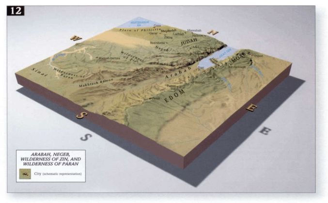
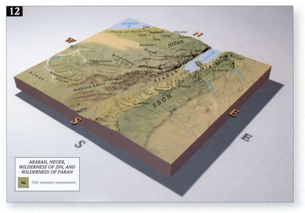
12. Relief map of Southern Arabah:
 Although this map seems to indicate that the Arabah is only south of the Dead Sea, it takes in much of the area around the
 Dead Sea on up along the River Jericho to the Sea of Galilee. From http://www.seektheoldpaths.com/Maps/012.jpg
13. What follows is the variety of ways this word is used in the Old Testament:
14. We find it used several times to refer to the plains of Moab. The first use of this word is often how we are to usually understand it, Num. 22:1 reads: And the sons of Israel journey and encamp in the plains [plural of Arabah] of Moab, beyond the Jordan, by Jericho. At this point, the Jews had moved northward parallel to the Dead Sea on its east side. We seem to have a more generic use of the word Arabah here, which indicates that they are in an arid, unpopulated area in Moab—sort of in contrast to the Land of Promise, which is a land flowing with milk and honey. We have the same usage in Num. 26:3, 63 31:12 33:48–50 35:1 36:13 Deut. 34:1 Joshua 13:32.
15. Arabah came to be used of the area east of the Dead Sea (which is mostly equivalent to the plains of Moab) and northward to take in the area east of the Jordan. This described, in part, the land given over to the tribe of Reuben (this would have been pastures, primarily).
1) Deut. 1:1–2 is quite specific here: These are the words which Moses spoke to all Israel beyond the Jordan; in the wilderness, in the Arabah, opposite to Suph, between Paran and Tophel, and Laban and Hazeroth, and Dizahab; eleven days from Horeb by way of Mount Seir to Kadesh-barnea. Beyond the Jordan means that we are east of the Jordan River (Deut. 3:20, 25). For much of the Exodus (in the 2nd half of Exodus, all of Leviticus and the first part of Numbers), Moses is moving northeast from Egypt, but camping primarily in the desert area south of Judah (they spend about 38 years here). Then, in Numbers, they begin moving northeast again, but this time coming up along side the Dead Sea and from that point, they mostly go north. The wilderness probably refers to most of their trek parallel to the Dead Sea (except when they ran into Moabites and Ammonites), and part of this would have been through the land south of the Dead Sea, which is what we would call the Arabah. It is unclear whether this term also applies to the area east of the Dead Sea and the Jordan River.
2) The and east of the Jordan and east of the Salt Sea is called the Arabah in the land agreement that Moses made with the tribe of Reuben. Deut. 3:17 4:49
3) This same area given to Reuben is called the plains of Moab in Deut. 34:1, 8.
16. Arabah was used to describe the area in which the Jews wandered, which included, the southern deserts below Judah. Arabah seems to be used in Psalm 68 with this significance.
17. The valley area around the Jordan River.
1) Abner, when excepting Joab, in 2Sam. 2:29, went through the Arabah, which is associated with crossing over the Jordan River; so this would be the valley around the Jordan River, more or less.
2) When Jerusalem is about to fall, Zedekiah’s army escapes Jerusalem and goes toward the arabah in 2Kings 25:4. They moved northeast across the Jordan, and were captured there. 2Kings 25:5 Jer. 39:4– 5 52:7–8
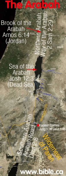
3) The River Jordan is called the river of the arabah in Amos 6:14.
4) We find the phrase, plains [fords] of the wilderness, in 2Sam. 15:28 17:16. However, in the first instance, scribes believed this to have been copied incorrectly, and that a similar word belongs here, rather than arabah. Strong’s #5679 BDB #720. The second time we find this, it appears to be the correct text, and Hushai is advising David to cross over the Jordan River, since Absalom may change his mind and come after him. Therefore the plains of the wilderness would refer to the arabah west of the Jordan.
18. The southern Judæan desert area.
1) When David was looking to get away from Saul, he moved into southern Judæa, which is called the Arabah in 1Sam. 23:24. This would be west of the Salt Sea in southern Judah.
2) In the Millennium, the waters of the Arabah will flow eastward into the Salt Sea, which will become a vibrant sea filled with fish. Flowing eastward indicates that we are talking about the Judæan area. Ezek. 47:6–10 (compare Zech. 14:8)
19. The way of the Arabah or the Arabah Road is found in 3 passages: Deut. 2:8 2Sam. 4:7 2Kings 25:4
1) I have checked several maps, and very few actually show where this is. Of the two below, both place the Way of the Arabah in the southern Arabah; but one has it going north-south (which was the intuitive location for me) but the MacMillan Bible Atlas has it going east-west.
2) Deut. 2:8 reads: So we passed by from our brothers the sons of Esau, who dwell in Seir, from the way of the Arabah from Elath and from Ezion Geber. We turned and passed by the way of the wilderness of Moab. The way my mind functions, I want to see where we started first, the second stop second, etc. Moses does not think this way;. He first mentions the sons of Esau, who would be directly below the Dead Sea. The Jews got to here by the Arabah Road from Elath and Ezion-Geber. These cities are on the northern tip of the Red Sea, which, if the Jews are traveling in a direct route, would be moving from south to north, making the connecting road (the way of the Arabah) north south (as we see in the first map).
3) 2Sam. 4:7–8 reads: Now when they came into the house, as he lay on his bed in his bedchamber, they struck him, and killed him, and beheaded him, and took his head, and went by the way of the Arabah all night. They brought the head of Ish-bosheth to David to Hebron, and said to the king, Behold, the head of Ish-bosheth, the son of Saul, your enemy, who sought your life; and Yahweh has avenged my lord the king this day of Saul, and of his seed. Hebron is about 25 miles south of Jerusalem. Ishbosheth is probably up in the area of Benjamin, so the Way of the Arabah in this passage would have been a north-south route, along the west side of the Dead Sea,
4) 2Kings 25:4–5 reads: Then a breach was made in the city, and all the men of war fled by night by the way of the gate between the two walls, which was by the king's garden (now the Chaldeans were against the city round about); and the king went by the way of the Arabah. But the army of the Chaldeans pursued after the king, and overtook him in the plains of Jericho; and all his army was scattered from him. So here, we are at Jerusalem, the Israeli army escapes going due north, where they are finally caught up in Jericho. So, this route is in keeping with the route named above.
5) What would seem to be the case is, the Way of the Arabah starts down at the northern tip of the Red Sea and then moves northward to Edom, and continues to move northward west of the Dead Sea. This is the most logical approach to me.
6) In the alternative, we have 2 routes here, the way of the Arabah running north-south running west of and parallel to the Dead Sea; and another road, given the same name, which is south of the Dead Sea (with possibly the same north-south direction). This would suggest that we are not necessarily looking at a specific, well-established name for these roads, but roads which are more or less named in the general sense, based upon the kind of area they are in (as they both are in the Arabah).
|
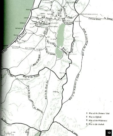
|
In the map above left, the Arabah Road is shown as going north-south through the Southern Arabah region. The map above right has the Arabah road as moving east-west across the middle of Southern Arabah. |
|
First map is from http://www.bible.ca/archeology/maps-bible-archeology-exodus-kadesh-barnea-arabah.jpg Second map is from The MacMillan Bible Atlas; 3rd Edition; Aharoni, Avi-Yonah, Rainey, and Safrai; MacMillan; ©1993 by Carta; p. 17. |
|
20. The Sea of the Arabah is another name for the Salt Sea (the Dead Sea). Deut. 3:17 4:49 Joshua 3:16 12:3 2Kings 14:25
1) The equivalence is made clear in Deut. 3:17 Joshua 12:3.
2) The Salt Sea is called the sea of the Arabah in Joshua 3:16, so much of the area around the Salt Sea in general is considered to be the Arabah.
3) Jeroboam II is said to have restored (northern) Israel’s borders from Lebo Ramath to the Sea of Arabah in 2Kings 14:25.
21. The word arabah simply means plains, wilderness, desert, unpopulated area and is also used metaphorically, which matches the desert wilderness of the land with the condition of men’s souls and motivations.
1) In Job 39:6, this is the area where the wild ass lives.
2) It and is used that way when affixed to the city of Jericho in Joshua 4:13 5:10.
3) This word is used this way with respect to Bethel and Ai in Joshua 8:14.
4) With the area south of Chinnereth in Joshua 11:2.
5) Arabah seems to just indicate a type of geographical area in Joshua 12:7–8: And these are the kings of the land whom Joshua and the sons of Israel struck beyond the Jordan westward, from Baal-gad in the Valley of Lebanon even to Mount Halak that goes up to Seir, which Joshua gave to the tribes of Israel for a possession according to their divisions; in the mountains, and in the Lowlands, and in the Arabah, and in the slopes, and in the wilderness, and in the Negeb; the Hittites, the Amorites, and the Canaanites, the Perizzites, the Hivites, and the Jebusites:... (and what follows is a list of those kings).
6) This word is used to describe the land when it languishes during the Tribulation in Isa. 33:9.
7) In Isa. 35:1–2, we see a changing of the desert wilderness area into great beauty, which is a description of the land of promise and how it changes in the Millennium. This transformation continues in Isa. 35:6–7, all of which indicates the relative barrenness of the Land of Promise in the future (future to Isaiah). Arabah is used again in contrast as to what God would do with the barrenness of the land during the Millennium in Isa. 41:19.
8) Interestingly enough, in Isa. 35, we have prophesies of Jesus Christ associated with the future blooming of Israel (His 1st and 2nd Advents are within this passage), we have Jesus coming to a world which is a metaphorical desert wilderness in Isa. 40 (arabah is found in 40:3). Arabah is used again in primarily a metaphorical way in Isa. 51:3.
9) Jeremiah uses arabah in this way in Jer. 2:6. Arabah is used in contrast to chasms. They did not say, 'Where is the LORD who brought us up from the land of Egypt, who led us in the wilderness, in a land of arabahs and pits, in a land of drought and deep darkness, in a land that none passes through, where no man dwells?'
10) Jeremiah uses this word in this way in Jer. 5:6: Therefore a lion from the forest shall strike them down; a wolf from the arabah [desert] shall devastate them. A leopard is watching their cities; everyone who goes out of them shall be torn in pieces, because their transgressions are many, their apostasies are great.
11) Jeremiah uses arabah in a metaphorical way in Jer. 17:5–7 Thus says the LORD: "Cursed is the man who trusts in man and makes flesh his strength, whose heart turns away from the LORD. He is like a shrub in the arabah, and shall not see any good come. He shall dwell in the parched places of the wilderness, in an uninhabited salt land. "Blessed is the man who trusts in the LORD, whose trust is the LORD.
12) God blasts Israel for its unfaithfulness and promises that Babylon would come and destroy them, but then warns Babylon of its eventual desolation as a nation in Jer. 50:11–13 (“Though you [Babylon] rejoice, though you exult, O plunderers of My heritage [Israel], though you frolic like a heifer in the pasture, and neigh like stallions, your mother shall be utterly shamed, and she who bore you shall be disgraced. Behold, she shall be the last of the nations, a wilderness, a dry land, and a desert [= arabah]. Because of the wrath of the LORD she shall not be inhabited but shall be an utter desolation; everyone who passes by Babylon shall be appalled, and hiss because of all her wounds.”). Babylon is situated in modern-day Iraq. We find this same theme in Jer. 51:41–43 “How Babylon is taken, the praise of the whole earth seized! How Babylon has become a horror among the nations! The sea has come up on Babylon; she is covered with its tumultuous waves. Her cities have become a horror, a land of drought and a desert [= arabah], a land in which no one dwells, and through which no son of man passes.”
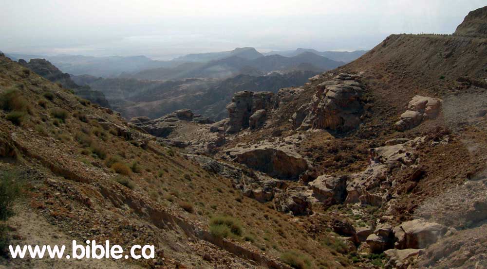
 Here is a photo which seems to convey the idea of the Arabah; it is taken from www.bible.ca
http://www.bible.ca/archeology/wilderness-of-zin-ascent-of-akrabbim-arabah-valley-west2.jpg
Here is a photo which seems to convey the idea of the Arabah; it is taken from www.bible.ca
http://www.bible.ca/archeology/wilderness-of-zin-ascent-of-akrabbim-arabah-valley-west2.jpg 13) There is an odd passage, which I do not quite get, but it seems to fit here. And the LORD will be king over all the earth. On that day the LORD will be one and his name one. The whole land shall be turned into a plain [= arabah] from Geba to Rimmon south of Jerusalem. But Jerusalem shall remain aloft on its site from the Gate of Benjamin to the place of the former gate, to the Corner Gate, and from the Tower of Hananel to the king's winepresses. And it shall be inhabited, for there shall never again be a decree of utter destruction. Jerusalem shall dwell in security (Zech. 14:9–11). It sounds here as if the city of Jerusalem will be suspended above this area.
22. Miscellaneous uses:
1) Arabah is also given to name the area west of the Jordan where the Canaanites live. Deut. 11:30
2) Arabah is used in an interesting way in Joshua 11:16. All of the areas which Joshua has conquered is listed in Joshua 11:16–17, which includes the Arabah.
(1) And Joshua took all this land: the heights, and all the Negeb, and all the land of Goshen, and the Lowlands, and the Arabah and the mountains of Israel, and its lowlands, from Mount Halak, that goes up to Seir, even to Baal-gad in the Valley of Lebanon, below Mount Hermon. And he took all their kings, and struck them, and killed them (Joshua 11:16–17).
(2) This is right after we have a very short section on Joshua taking northern Israel (Joshua 11:1–15).
(3) However, given the mention of the Negev and the land of Goshen (a city of Judah), areas in southern Israel, it is clear that this list includes pretty much all of the area that Joshua had conquered up to that point.
(4) Given the way the Arabah as been used already, I will hypothesize that this refers to the area east of the Jordan, to more or less describe the land given to Reuben, Gad and Manasseh before the Jews actually entered into the Land of Promise.
(5) So, even though arabah is used in conjunction with some particular cities, as above, here, it appears to be used more as a specific area apart from those cities.
(6) This understanding seems to be confirmed in Joshua 12:1, 3 where the Arabah is associated with the lands east of the Jordan.
23. There is a city in northern Judah called Beth-Arabah, which is on the border of Judæa and Benjamin. It has this name, more than likely, because of its proximity to the Arabah around the Jordan River. Joshua 15:6 18:18
24. ZPEB
![]() on the geology of this region: There is an enormous fault line in the crust of the earth from northern
Syria all the way through the Red Sea down the southeastern coast of Africa. On the western side of the
arabah, which is below sea level, there are limestone cliffs along the border which are 2000 to 3000 ft. high.
On the other side are sandstone and granite rocks which are capped with limestone, which also rise up 2000
to 3000 feet. So, in between these sets of mountains, there has probably been a drop of 2000–3000 ft.,
which makes up this valley area.
on the geology of this region: There is an enormous fault line in the crust of the earth from northern
Syria all the way through the Red Sea down the southeastern coast of Africa. On the western side of the
arabah, which is below sea level, there are limestone cliffs along the border which are 2000 to 3000 ft. high.
On the other side are sandstone and granite rocks which are capped with limestone, which also rise up 2000
to 3000 feet. So, in between these sets of mountains, there has probably been a drop of 2000–3000 ft.,
which makes up this valley area.
25. ISBE
![]() on the geology of this region:
on the geology of this region:
1) The Arabah in its whole extent occupies a portion of the great geological fault or crevasse in the earth's crust which extends from Antioch near the mouth of the Orontes southward between the Lebanon and the Anti-Lebanon Mountains to the valley of the Jordan and the Dead Sea, and onward to the Gulf of Akabah, whence it can be traced with considerable probability through the Red Sea and the interior lakes of Africa. The most remarkable portion of this phenomenal crevasse is that which extends from the Waters of Merom to the springs of Ain Abu Werideh; for through this entire distance the Arabah is below sea-level, the depression at the Dead Sea being approximately 1,292 feet. See DEAD SEA. Throughout the entire distance from the Waters of Merom to the watershed, 45 miles from Akabah, the western side of the Arabah is bordered by strata of Cretaceous (chalk) limestone rising pretty continuously to a height of from 2,000 to 3,000 feet above sea-level, no older rocks appearing upon that side. But upon the eastern side older sandstones (Nubian and lower Carboniferous) and granitic rocks border the plain, supporting, however, at a height of 2,000 or 3,000 feet Cretaceous limestones corresponding to those which descend to the level of the gorge on the western side. Throughout this entire distance, therefore, the strata have either slipped down upon the western side or risen upon the eastern side, or there has been a movement in both directions. The origin of this crevasse dates from the latter part of the Cretaceous or the early part of the Tertiary period.
2) But in post-Tertiary times an expanded lake filled the region, extending from the Waters of Merom to Ain Abu Werideh, a distance of about 200 miles, rising to an elevation of about 1,400 feet above the present level of the Dead Sea, but not sufficiently high to secure connection with the ocean either through the Arabah proper or across the valley of Esdraelon. This body of water was, on the average, 30 miles wide and over the northern part of the Dead Sea had an extreme depth of 2,700 feet. The most distinct evidence of the existence of this enlargement of the lake is to be found at Ain Abu Werideh, where Hull reports “banks of horizontally stratified materials ... sometimes of coarse material, such as gravel; at other times consisting of fine sand, loam, or white marl, with very even stratification, and containing blanched semi-fossil shells of at least two kinds of univalves, which Professor Haddon has determined to be Melania tuberculata Müll, and Melanopsis Saulcyi, Bourg” (Mount Seir, 99, 100). These are shells which are now found, according to Tristram, in great numbers in semi-fossil condition in the marl deposits of the Dead Sea, and both of these genera are found in the fluvio-marine beds formed in the brackish or salt water of the Isle of Wight. The existence of the shells indicates the extent to which the saline waters of the Dead Sea were diluted at that time. It should be added, however, that species somewhat similar still exist around the borders of the Dead Sea in lagoons where fresh water is mingled in large quantities with that of the Dead Sea. This is especially true in eddies near the mouth of the Jordan. (See Merrill, East of the Jordan.) Huntington in 1909 confirms the fact that these high-level shore lines are found on both sides of the Dead Sea, though for some reason the have not been traced farther north.
3) At lower levels, especially at that which is 650 feet above the Dead Sea, there is, however, a very persistent terrace of gravel, sand and clay marking a shore line all the way from the south end of the Dead Sea to Lake Galilee. This can be seen running up into all the wadies on either side, being very prominent opposite their mouths, but much eroded since its deposition. On the shores of the lake between the wadies the line is marked by a slight accumulation of coarse material. Below the 650-foot line there are several other minor strands marking periods when the subsiding waters were for a short time stationary.
4) This period of enlargement of the waters in the Arabah is now, with abundant reason, correlated with the Glacial epoch whose influence was so generally distributed over the northern hemisphere in early post-Tertiary times. There were, however, no living glaciers within the limits of the Arabah Valley - Mount Hermon not being sufficiently large to support any extensive ice-sheet. The nearest glacier of any extent was on the west side of the Lebanon Mountains, 40 to 50 miles north of Beirût, where according to my own observations one descended from the summit of the mountains (10,000 feet high) 12 miles down the valley of the Kadesha River to a level 5,500 feet above the sea, where it built up an immense terminal moraine several miles across the valley, and 5 miles up it from its front, upon which is now growing the celebrated grove of the Cedars of Lebanon. (See Records of the Past, Am. series, V, 195-204.) The existence of the moraine, however, had been noted by Sir Joseph Hooker forty years before. (See Nat. Hist. Rev., January, 1862.)
5) But while there were no glaciers in the Arabah Valley itself, there, as elsewhere, semi-glacial conditions extended beyond the glacial limits a considerable distance into the lower latitudes, securing the increased precipitation and the diminished evaporation which would account for the enlargement of the bodies of water occupying enclosed basins within reach of these influences. The basin of Great Salt Lake in Utah presents conditions almost precisely like those of the Arabah, as do the Caspian and Aral seas, and lakes Urumiah, Van, and various others in central Asia. During the Glacial epoch the water level of Great Salt Lake rose more than 1,000 feet higher than now and covered ten times its present area. At the same time the Aral Sea discharged into the Caspian Sea through an outlet as large as Niagara. When the conditions of the Glacial epoch passed away the evaporation again prevailed, until the water areas of these enclosed basins were reduced to the existing dimensions and the present equilibrium was established between the precipitation and the evaporation.
6) While it is susceptible of proof that the close of this epoch was geologically recent, probably not more than 10,000 years ago (see Wright, Ice Age in North America, 5th edition, chapter xx),the present conditions had become established approximately long before the time of Abraham and the development of civilization in Babylonia and Egypt.
7) East of the Arabah between the Dead Sea and Akabah numerous mountain peaks rise to the height of more than 4,000 feet above tide level, the highest being Mount Hor, though back of it there is a limestone range reaching 5,000 feet. This mountainous region contains numerous fertile areas and furnishes through its numerous wadies a considerable amount of water to favor vegetation. The limestone floor of the Arabah south of the Dead Sea is deeply covered with sand and gravel, washed in from the granitic areas from the east. This greatly favors the accumulation of sediment at the mouths of the wadies emptying into the south end of the Ghôr.
The information in the doctrines below are summations of the doctrine above.
Since brevity is the soul of wit, let me reduce this doctrine in size. |
1. ʿĂrâbâh (עֲרָבָה) [pronounced guh-rawb-VAW] is transliterated arabah. In general, the Arabah is the unpopulated and desert area extending up from the northeastern tip of the Red Sea, on up along the eastern site of the Dead Sea on up to the Sea of Galilee. This also takes in the area around the Jordan River and some portions in southern Judæa. The first 6 or 7 uses below are subsets of that land mass. The context of the passage will indicate just exactly what portion is being referred to. 2. Arabah is found 61 times in the Old Testament, but only translated Arabah twice in the KJV. In the KJV, this word is translated 9 different ways (3 of which are quite different from what we would expect—champaign, evenings, and heavens). |
3. The meanings given this word: 1) BDB: desert plain, steppe, desert, wilderness. 2) Gesenius: an arid, sterile region, a desert. With the definite article, this refers to that low region into which the valley of the Jordan runs near Jericho, and which extends as far as the Ælanitic gulf. It is also used to refer to a city in Benjamin (Beth Arabah). 3) Strong’s: From H6150 (in the sense of sterility); a desert; especially (with the article prefixed) the (generally) sterile valley of the Jordan and its continuation to the Red Sea. Strong’s #6160 BDB #787. 4) ISBE: This word indicates in general a barren district, but is specifically applied in whole or in part
to the depression of the Jordan valley, extending from Mount Hermon to the Gulf of Aqaba.
|
4. Just as we have thousands of areas named with the word desert in it (Mojave Desert, the Arabian Desert, etc.), this term is used for a number of different geographical areas throughout the Palestine area and beyond, where there are generally unpopulated arid, rocky and barren hills and mountains. |
5. The root word is ʿârab (עָרַב) [pronounced ģaw-RAHBV], which means to be arid, to be sterile (we recognize this word as Arab). This verb form and meaning is not found in the Old Testament (there are 4 verbs wit this same spelling, some which are used and some which are not). You may recognize the transliteration of this word and its substantive cognate as Arab. Strong’s #none (related to #6152) BDB #787. 6. One possible key appears to be the use of the definite article in front of this word; then it seems to signify a particular area. Without that definite article, it appears to designate an area with those same characteristics (this is a theory; I have not examined all of the passages yet). In the plural construct, it is generally associated with Moab or Jericho (as in, the plains of Moab). |
 Although this map seems to indicate that the Arabah is only south of the Dead Sea, it takes in much of the area around the Although this map seems to indicate that the Arabah is only south of the Dead Sea, it takes in much of the area around the Dead Sea on up along the River Jericho to the Sea of Galilee. From http://www.seektheoldpaths.com/Maps/012.jpg
|
Although the graphic above only has the section between the Dead Sea and the Gulf of Aqaba denoted as the Arabah, this actually extends further north, all the way up the Jordan River to the southern tip of the Sea of Galilee (neither of which is shown on this map). |
7. ISBE’s description: The southern portion, which still retains the name of Arabah, is included in the
wilderness of Zin (Num. 34:3). According to the survey of Lord Kitchener and George Armstrong made
in 1883, under the auspices of the Palestine Exploration Fund, its length from the head of the Gulf of
Akabah to the Dead Sea is 112 miles. The lowest point of the watershed is 45 miles from Akabah, and
660 feet above tide (1,952 above the Dead Sea). The average width of the valley up to this point is about
6 miles, but here a series of low limestone ridges (called Er Risheh) rising 150 feet above the plain runs
obliquely across it for a distance of 10 miles, narrowing it up to a breadth of about one–half mile. North
of this point, opposite Mount Hor, the valley widens out to 13 miles and then gradually narrows to 6 miles
at the south end of the Dead Sea. At Ain Abu Werideh, 29 miles north of the watershed, the valley is at
the sea–level – 1,292 feet above that of the Dead Sea. North of the watershed, the main line of drainage
is the Wady el–Jeib, which everywhere keeps pretty close to the west side of the valley. At Ain Abu
Werideh it is joined by numerous wadies descending from the Edomite mountains on the east, which
altogether water an oasis of considerable extent, covered with a thicket of young palms, tamarisks,
willows and reeds. Twenty–four miles farther north the Arabah breaks down suddenly into the valley of
the Dead Sea, or the Ghôr, as it is technically called. Lord Kitchener's report is here so vivid as to be
worthy of literal reproduction. “The descent to the Ghôr was down a sandy slope of 300 feet, and the
change of climate was most marked, from the sandy desert to masses of tangled vegetation with streams
of water running in all directions, birds fluttering from every tree, the whole country alive with life; nowhere
have I seen so great and sudden a contrast” (Mount Seir, 214). The descent here described was on the
eastern side of the semicircular line of cliffs formed of sand, gravel, and marl which enclose the Ghôr at
the south end, and which are probably what are referred to in Joshua 15:3 as the “ascent of Akrabbim.”
The ordinary route, however, leading to the plain of the Arabah from the Dead Sea is up the trough worn
by the Wady el–Jeib along the west side of the valley. But this route would be impracticable during the
rainy season after the cloudbursts which occasionally visit this region, when torrents of water pour down
it, sufficient to roll boulders of considerable size and to transport an immense amount of coarse sediment.
South of the Dead Sea a muddy plain, known as the Sebkah, extends 6 miles, filling about one–half of
the width of the Ghôr. During most of the year the mud over this area is so thin and deep that it is
impossible to cross it near its northern end. This whole area between the “ascent of Akrabbim” and the
Dead Sea has evidently been greatly transformed by the sedimentary deposits which have been brought
in by the numerous tributary wadies during the last 4,000 years, the coarser material having encroached
upon it from either side, and the fine material having been deposited over the middle portion, furnishing
the clay which is so embarrassing to travelers
|
8. Even though we are going to find this word used in several different ways, the various writers of Scripture clearly had these uses separate in their minds when they wrote. |
9. ZPEB
|
10. We have one possible passage which takes in most of this area. The psalmist calls for the reader to Sing to God, sing praise to His name; lift up a song for Him who rides in the arabah’s, by His name Jehovah; yea, exult in His presence in Psalm 68:4. The plural use of arabah may purposely include the various regions which are given that name. This, at first, can be a very difficult passage to interpret, mostly because of the KJV’s poor translation here (they translate arabah as heavens here). Because of this, many other translations follow suit. The exegesis of Psalm 68 is found here: http://kukis.org/Psalms/Psalm068.htm |
11. We find it used several times to refer to the plains of Moab in Num. 22:1 26:3, 63 31:12 33:48–50 35:1 36:13 Deut. 2:8 34:1 Joshua 13:32. In most of these passages, the Jews had moved northward parallel to the Dead Sea on its east side. We seem to have a more generic use of the word Arabah here, which indicates that they are in an arid, unpopulated area in Moab, which is in stark contrast to the Land of Promise, which is a land flowing with milk and honey. |
12. Arabah came to be used of the area east of the Dead Sea (which is mostly equivalent to the plains of Moab) and northward to take in the area east of the Jordan. This described, in part, the land given over to the tribe of Reuben (this would have been pastures, primarily). Deut. 1:1–2 3:17, 20, 25 4:49 34:1, 8 |
13. The arabah is the valley area around the Jordan River. 2Sam. 2:29 4:7 2Kings 25:4–5 Jer. 39:4– 5 52:7–8 Amos 6:14 14. The southern Judæan desert area. 1) When David was looking to get away from Saul, he moved into southern Judæa, which is called the Arabah in 1Sam. 23:24. This would be west of the Salt Sea in southern Judah. 2) In the Millennium, the waters of the Arabah will flow eastward into the Salt Sea, which will become a vibrant sea filled with fish. Flowing eastward indicates that we are talking about the Judæan area. Ezek. 47:6–10 (compare Zech. 14:8) |
15. The Sea of the Arabah is another name for the Salt Sea (the Dead Sea). Deut. 3:17 4:49 Joshua 3:16 12:3 2Kings 14:25 The equivalence is made clear in Deut. 3:17 Joshua 12:3. |
16. The way of the Arabah or the Arabah Road is found in 3 passages: Deut. 2:8 2Sam. 4:7 2Kings 25:4 1) I have checked several maps, and very few actually show where this is. Of the two which I found, both place the Way of the Arabah in the southern Arabah (south of the Dead Sea); but one has it going north-south (which was the intuitive location for me) but the MacMillan Bible Atlas has it going east-west. 2) Deut. 2:8 reads: So we passed by from our brothers the sons of Esau, who dwell in Seir, from the way of the Arabah from Elath and from Ezion Geber. We turned and passed by the way of the wilderness of Moab. Moses first mentions the sons of Esau, who would be directly below the Dead Sea. The Jews got to here by the Arabah Road from Elath and Ezion-Geber. These cities are on the northern tip of the Red Sea, which, if the Jews are traveling in a direct route, would be moving from south to north, making the connecting road (the way of the Arabah) north-south. 3) 2Sam. 4:7–8 reads: Now when they came into the house, as he lay on his bed in his bedchamber, they struck him, and killed him, and beheaded him, and took his head, and went by the way of the Arabah all night. They brought the head of Ish-bosheth to David to Hebron, and said to the king, Behold, the head of Ish-bosheth, the son of Saul, your enemy, who sought your life; and Yahweh has avenged my lord the king this day of Saul, and of his seed. Hebron is about 25 miles south of Jerusalem. Ishbosheth is probably up in the area of Benjamin, so the Way of the Arabah in this passage would have been a north-south route, along the west side of the Dead Sea, 4) 2Kings 25:4–5 reads: Then a breach was made in the city, and all the men of war fled by night by the way of the gate between the two walls, which was by the king's garden (now the Chaldeans were against the city round about); and the king went by the way of the Arabah. But the army of the Chaldeans pursued after the king, and overtook him in the plains of Jericho; and all his army was scattered from him. So here, we are at Jerusalem, the Israeli army escapes going due north, where they are finally caught up in Jericho. So, this route is in keeping with the route named above. 5) What would seem to be the case is, the Way of the Arabah starts down at the northern tip of the Red Sea and then moves northward to Edom, and continues to move northward west of the Dead Sea. This is the most logical approach to me. |
17. The word arabah simply means plains, wilderness, desert, unpopulated area (Joshua 4:13 5:10 8:14 11:2 Isa. 33:9 Jer. 5:6). It is also used in a metaphorical sense, which matches the desert wilderness of the land with the condition of men’s souls and motivations (Isa. 51:3). 1) In Job 39:6, this is the area where the wild ass lives. 2) Arabah seems to just indicate a type of geographical area in Joshua 12:7–8.  Here is a photo which seems to convey the idea of the Arabah; it is taken
from www.bible.ca Here is a photo which seems to convey the idea of the Arabah; it is taken
from www.bible.cahttp://www.bible.ca/archeology/wilderness-of-zin-ascent-of-akrabbim-arabah-valley-west2.jpg 3) In Isa. 35:1–2, we see a changing of the desert wilderness area into great beauty, which is a description of the land of promise and how it changes in the Millennium. See also Isa. 35:6–7 41:19. God will take the barrenness of the Land of Promise in the future (future to Isaiah) and transform it. 4) Jesus will come to a world which is a metaphorical desert wilderness in Isa. 40 (arabah is found in 40:3). 5) Jeremiah uses arabah in a metaphorical way in Jer. 17:5–7 Thus says the LORD: "Cursed is the man who trusts in man and makes flesh his strength, whose heart turns away from the LORD. He is like a shrub in the arabah, and shall not see any good come. He shall dwell in the parched places of the wilderness, in an uninhabited salt land. "Blessed is the man who trusts in the LORD, whose trust is the LORD. 6) God blasts Israel for its unfaithfulness and promises that Babylon would come and destroy them, but then warns Babylon of its eventual desolation as a nation in Jer. 50:11–13 (“Though you [Babylon] rejoice, though you exult, O plunderers of My heritage [Israel], though you frolic like a heifer in the pasture, and neigh like stallions, your mother shall be utterly shamed, and she who bore you shall be disgraced. Behold, she shall be the last of the nations, a wilderness, a dry land, and a desert [= arabah]. Because of the wrath of the LORD she shall not be inhabited but shall be an utter desolation; everyone who passes by Babylon shall be appalled, and hiss because of all her wounds.”). Babylon is situated in modern-day Iraq. We find this same theme in Jer. 51:41–43 “How Babylon is taken, the praise of the whole earth seized! How Babylon has become a horror among the nations! The sea has come up on Babylon; she is covered with its tumultuous waves. Her cities have become a horror, a land of drought and a desert [= arabah], a land in which no one dwells, and through which no son of man passes.” |
18. Miscellaneous uses: 1) Arabah is also given to name the area west of the Jordan where the Canaanites live. Deut. 11:30 2) Arabah is used in an interesting way in Joshua 11:16. All of the areas which Joshua has conquered is listed in Joshua 11:16–17, which includes the Arabah, which would reasonably understood as taking the land east of the Jordan, which was then given to Reuben. 19. There is a city in northern Judah called Beth-Arabah, which is on the border of Judæa and Benjamin. It has this name, more than likely, because of its proximity to the Arabah around the Jordan River. Joshua 15:6 18:18 |
The complete doctrine can be found at: http://kukis.org/Doctrines/Arabah.htm and the pdf version is at http://kukis.org/Doctrines/Arabah.pdf . |
Since brevity is the soul of wit, let me reduce this doctrine in size. |
1. ʿĂrâbâh (עֲרָבָה) [pronounced guh-rawb-VAW] is transliterated arabah. In general, the Arabah is the unpopulated and desert area extending up from the northeastern tip of the Red Sea, on up along the eastern site of the Dead Sea on up to the Sea of Galilee. This also takes in the area around the Jordan River and some portions in southern Judæa. The first 6 or 7 uses below are subsets of that land mass. The context of the passage will indicate just exactly what portion is being referred to. 2. Arabah means desert plain, an arid, sterile region; a desert, a wilderness. With the definite article, this refers to that low region into which the valley of the Jordan runs near Jericho, and which extends as far as the Ælanitic gulf. It is also used to refer to a city in Benjamin (Beth Arabah). 3. Just as we have thousands of areas named with the word desert in it (Mojave Desert, the Arabian Desert, etc.), this term is used for a number of different geographical areas throughout the Palestine area and beyond, where there are generally unpopulated arid, rocky and barren hills and mountains. 4. The root word is ʿârab (עָרַב) [pronounced ģaw-RAHBV], which means to be arid, to be sterile (we recognize this word as Arab). |
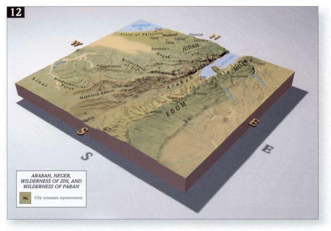 Although this map seems to indicate that the Arabah is only south of the Dead Sea, it takes in much of the area around the Although this map seems to indicate that the Arabah is only south of the Dead Sea, it takes in much of the area around the Dead Sea on up along the River Jericho to the Sea of Galilee. From http://www.seektheoldpaths.com/Maps/012.jpg
|
Although the graphic above only has the section between the Dead Sea and the Gulf of Aqaba denoted as the Arabah, this actually extends further north, all the way up the Jordan River to the southern tip of the Sea of Galilee (neither of which is shown on this map). |
5. Even though we are going to find this word used in several different ways, the various writers of Scripture clearly had these uses separate in their minds when they wrote. |
6. ZPEB
|
7. We have one possible passage which takes in most of this area. The psalmist calls for the reader to Sing to God, sing praise to His name; lift up a song for Him who rides in the arabah’s, by His name Jehovah; yea, exult in His presence in Psalm 68:4. The plural use of arabah may purposely include the various regions which are given that name. This, at first, can be a very difficult passage to interpret, mostly because of the KJV’s poor translation here (they translate arabah as heavens here). Because of this, many other translations follow suit. The exegesis of Psalm 68 is found here: http://kukis.org/Psalms/Psalm068.htm |
8. We find it used several times to refer to the plains of Moab, which is east of the Dead Sea. Num. 22:1 26:3, 63 31:12 33:48–50 35:1 36:13 Deut. 2:8 34:1 Joshua 13:32. Arabah is used here to indicates that they are in an arid, unpopulated area in Moab, which is in stark contrast to the Land of Promise, which is a land flowing with milk and honey. |
9. Arabah came to be used of the area east of the Dead Sea (which is mostly equivalent to the plains of Moab) and northward to take in the area east of the Jordan. This is, in part, the land given over to the tribe of Reuben (this would have been pastures, primarily). Deut. 1:1–2 3:17, 20, 25 4:49 34:1, 8 |
10. The arabah is the valley area around the Jordan River. 2Sam. 2:29 4:7 2Kings 25:4–5 Jer. 39:4– 5 52:7–8 Amos 6:14 11. The southern Judæan desert area. 1Sam. 23:24 Ezek. 47:6–10 (compare Zech. 14:8) |
12. The Sea of the Arabah is another name for the Salt Sea (the Dead Sea). Deut. 3:17 Joshua 12:3 |
13. The way of the Arabah or the Arabah Road seems to be a north-south route or road which begins at the northern tip of the Red Sea, in Elath and Ezion-Geber, and moves northward to Edom (south of the Dead Sea), and then either continues or starts up again west of the Dead Sea running from at least Hebron (25 miles south of Jerusalem) to Jericho (north of Jerusalem). Deut. 2:8 2Sam. 4:7 2Kings 25:4. |
14. The word arabah simply means plains, wilderness, desert, unpopulated area (Joshua 4:13 5:10 8:14 11:2 12:7–8 Job 39:6 Isa. 33:9 Jer. 5:6 50:11–13). It is also used in a metaphorical sense, which matches the desert wilderness of the land with the condition of men’s souls and motivations (Isa. 51:3). 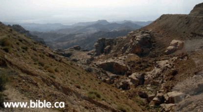 Here is a photo which seems to convey the idea of the Arabah; it is taken
from www.bible.ca Here is a photo which seems to convey the idea of the Arabah; it is taken
from www.bible.cahttp://www.bible.ca/archeology/wilderness-of-zin-ascent-of-akrabbim-arabah-valley-west2.jpg 1) In Isa. 35:1–2, we see a changing of the desert wilderness area into great beauty, which is a description of the land of promise and how it changes in the Millennium. See also Isa. 35:6–7 41:19. God will take the barrenness of the Land of Promise in the future (future to Isaiah) and transform it. 2) Jesus will come to a world which is a metaphorical desert wilderness in Isa. 40 (arabah is found in 40:3). 3) Jeremiah uses arabah in a metaphorical way in Jer. 17:5–7 Thus says the LORD: "Cursed is the man who trusts in man and makes flesh his strength, whose heart turns away from the LORD. He is like a shrub in the arabah, and shall not see any good come. He shall dwell in the parched places of the wilderness, in an uninhabited salt land. "Blessed is the man who trusts in the LORD, whose trust is the LORD. |
15. Miscellaneous uses: 1) Arabah is also given to name the area west of the Jordan where the Canaanites live. Deut. 11:30 2) Arabah is used in an interesting way in Joshua 11:16. All of the areas which Joshua has conquered is listed in Joshua 11:16–17, which includes the Arabah, which would reasonably understood as taking the land east of the Jordan, which was then given to Reuben. 3) There is a city in northern Judah called Beth-Arabah, which is on the border of Judæa and Benjamin. It has this name, more than likely, because of its proximity to the Arabah around the Jordan River. Joshua 15:6 18:18 |
The complete doctrine can be found at: http://kukis.org/Doctrines/Arabah.htm and the pdf version is at http://kukis.org/Doctrines/Arabah.pdf . |
The word Arabah is used over 60 times in the Bible, so it would be helpful to note the way in which this word is used: |
1. Most understand the Arabah to refer to a thin stretch of land which extends all the way from the southern tip of the Sea of Galilee, around the Jordan River, around the Dead Sea (principally on the east side), and then extending down from the southern tip of the Dead Sea to the northern tip of the Red Sea. Psalm 68:4 is one of the few passages which probably takes in that entire area. 2. The area most commonly noted on a map called the Arabah is that strip of land between the southern tip of the Dead Sea down to the northern tip of the Red Sea. |
 Although this map seems to indicate that the Arabah is only south of the Dead Sea, it takes in much of the area around the
Dead Sea on up along the River Jericho to the Sea of Galilee. From http://www.seektheoldpaths.com/Maps/012.jpg Although this map seems to indicate that the Arabah is only south of the Dead Sea, it takes in much of the area around the
Dead Sea on up along the River Jericho to the Sea of Galilee. From http://www.seektheoldpaths.com/Maps/012.jpg
|
3. The word arabah simply means plains, wilderness, desert, unpopulated area (Joshua 4:13 5:10 8:14 11:2 12:7–8 Job 39:6 Isa. 33:9 Jer. 5:6 50:11–13). It is also used in a metaphorical sense, which matches the desert wilderness of the land with the condition of men’s souls and motivations (Isa. 51:3). 4. Just as we have thousands of areas named with the word desert in it (Mojave Desert, the Arabian Desert, etc.), this term is used for a number of different geographical areas throughout the Palestine area and beyond, where there are generally unpopulated arid, rocky and barren hills and mountains. Given this meaning of the word, there are a number of places throughout the Bible which are called the Arabah, but it is possibly to be taken in a more general sense. |
5. We have one possible passage which takes in most of this area. The psalmist calls for the reader to Sing to God, sing praise to His name; lift up a song for Him who rides in the arabah’s, by His name Jehovah; yea, exult in His presence in Psalm 68:4. The plural use of arabah may purposely include the various regions which are given that name. This, at first, can be a very difficult passage to interpret, mostly because of the KJV’s poor translation here (they translate arabah as heavens here). Because of this, many other translations follow suit. The exegesis of Psalm 68 is found here: http://kukis.org/Psalms/Psalm068.htm |
6. We find it used several times to refer to the plains of Moab, which is east of the Dead Sea. Num. 22:1 26:3, 63 31:12 33:48–50 35:1 36:13 Deut. 2:8 34:1 Joshua 13:32. Arabah is used here to indicates that they are in an arid, unpopulated area in Moab, which is in stark contrast to the Land of Promise, which is a land flowing with milk and honey. |
7. Arabah came to be used of the area east of the Dead Sea (which is mostly equivalent to the plains of Moab) and northward to take in the area east of the Jordan. This is, in part, the land given over to the tribe of Reuben (this would have been pastures, primarily). Deut. 1:1–2 3:17, 20, 25 4:49 34:1, 8 |
8. The arabah is the valley area around the Jordan River. 2Sam. 2:29 4:7 2Kings 25:4–5 Jer. 39:4– 5 52:7–8 Amos 6:14 9. The southern Judæan desert area. 1Sam. 23:24 Ezek. 47:6–10 (compare Zech. 14:8) |
10. The Sea of the Arabah is another name for the Salt Sea (the Dead Sea). Deut. 3:17 Joshua 12:3 |
11. The way of the Arabah or the Arabah Road seems to be a north-south route or road which begins at the northern tip of the Red Sea, in Elath and Ezion-Geber, and moves northward to Edom (south of the Dead Sea), and then either continues or starts up again west of the Dead Sea running from at least Hebron (25 miles south of Jerusalem) to Jericho (north of Jerusalem). Deut. 2:8 2Sam. 4:7 2Kings 25:4. |
The complete doctrine can be found at: http://kukis.org/Doctrines/Arabah.htm and the pdf version is at http://kukis.org/Doctrines/Arabah.pdf . |
Although I construct any doctrine first directly from the Bible, I always then refer to the other sources which I have, just in case I have missed anything. |
1. Andrew Robert Fausset, Fausset’s Bible Dictionary; from e-Sword, topic: Arabah. 2. The International Standard Bible Encyclopedia; James Orr, Editor; ©1956 Wm. B. Eerdmans Publishing Co.; Ⓟ by Hendrickson Publishers; from E-Sword; Topic: Arabah. 3. Dr. William Smith, Smith’s Bible Dictionary; 1894; from e-Sword, topic: Arabah. 4. The Zondervan Pictorial Encyclopedia of the Bible; Merrill Tenney, ed., Zondervan Publishing House, ©1976; Vol. 1, pp. 233–235. |